
Research Studies in R2R Watersheds & Relevant Links
Observations of Coastal Circulation, Waves, and Sediment Transport along West Maui, Hawaiʻi , and Modeling Effects of Potential Watershed Restoration on Decreasing Sediment Loads to Adjacent Coral Reefs
Open file report 2022-1121
Terrestrial sediment discharging from watersheds off West Maui, Hawaiʻi, has been documented as a primary stressor to local coral reefs, causing coral reef health to decline. The U.S. Geological Survey acquired and analyzed physical oceanographic and sedimentologic field data off the coast of West Maui to calibrate and validate physics-based, numerical hydrodynamic and sediment transport models of the study area developed by Deltares. These models simulated terrestrial sediment transport and dispersal from West Maui watersheds into coastal waters and how terrestrial sediment affects nearby coral reefs under different oceanographic forcing and watershed restoration scenarios. Storlazzi, C.D., Cheriton, O.M., Cronin, K.M., van der Heijden, L.H., Winter, G., Rosenberger, K.J., Logan, J.B., and McCall, R.T., 2023, Observations of coastal circulation, waves, and sediment transport along West Maui, Hawaiʻi (November 2017–March 2018), and modeling effects of potential watershed restoration on decreasing sediment loads to adjacent coral reefs: U.S. Geological Survey Open-File Report 2022–1121, 73 p., https://doi.org/10.3133/ofr20221121. Sediment Budget for Watersheds of West Maui, Hawaii
Story Map Summary here
Scientific Investigations Report 2020–5133: Episodic runoff brings suspended sediment to West Maui’s nearshore waters, turning them from blue to brown. This pollution degrades the ecological, cultural, and recreational value of these iconic nearshore waters. We used mapping, monitoring, and modeling to identify and quantify the watershed sources for fine sediment that pollutes the nearshore each year. These results focus strategies to reduce pollution on the outstanding sources for this sediment. Terrestrial runoff causing coastal plumes now occurs when two or more hours of rain falls at rates greater than 10–20 millimeter (mm) per hour in source watersheds. Analysis of recent and historical rainfall indicates that West Maui communities can expect rainfalls to bring coastal plumes at least 3–5 times per year. Former agricultural fields and some unimproved roads are possible sources for the fine sediment of these plumes. We found, however, that these obvious sources do not produce plumes during small annual storms, because they drain water at rates that far exceed most annual rainfalls and because there is no evidence for runoff from rains that caused recent plumes. Streambanks now eroding into historic fill terraces of sands, silts, and clays are a more plausible source. These terraces are found only downstream of historical agricultural fields and are composed of silt and fine sand. Surveys show that the fill terraces occupy ~40 percent of streambank length, making them extensive. During 2015–2016, these deposits eroded at median rates of 5–24 mm per year. Summed over West Maui’s watersheds, these rates imply sediment loads carried to the coast that can be ten times or more than modeled pre-human values. A sediment budget indicates that bank erosion of fill terraces from a few watersheds likely dominates the current annual fine sediment load to the nearshore, with Kahana Stream watershed producing the largest annual input of 285 metric tons, the equivalent of 29 dump-truck loads every year. Although past large storms have contributed to sediment loading, annual plume generation is now caused by smaller rainfalls eroding these near-stream terrace deposits, a legacy of historic agriculture. Treatments of former agricultural fields, roads, and reserve forests are consequently not likely to measurably effect sediment pollution from smaller, more frequent storms. Increased runoff from residential and commercial development of West Maui has the potential to exacerbate sediment plumes from such storms. Stock, J.D., and Cerovski-Darriau, Corina, 2021, Sediment budget for watersheds of West Maui, Hawaii: U.S. Geological Survey Scientific Investigations Report 2020–5133, 61 p., 1 plate, scale 1:25,000, https://doi.org/10.3133/sir20205133. The Atlas of the Reefs of West Maui
Released March 2020: The Nature Conservancy released the “Atlas of the Reefs of West Maui,” a comprehensive report compiling 20 years of data detailing changes in the abundance and diversity of marine life in West Maui. The ‘first-of-its-kind’ atlas includes data collected by public and private organizations at 2,600 sites stretching from the “Pali” Tunnel on Honoapiʻilani Highway to Līpoa Point north of Honolua Bay.
Citation: Minton, D., Carr, R., Fielding, E., & Conklin, E. 2020. Atlas of the Reefs of West Maui. The Nature Conservancy Hawai‘i. Honolulu, HI 97817. 228 pp. Maui-area coral reefs described in detail, including threats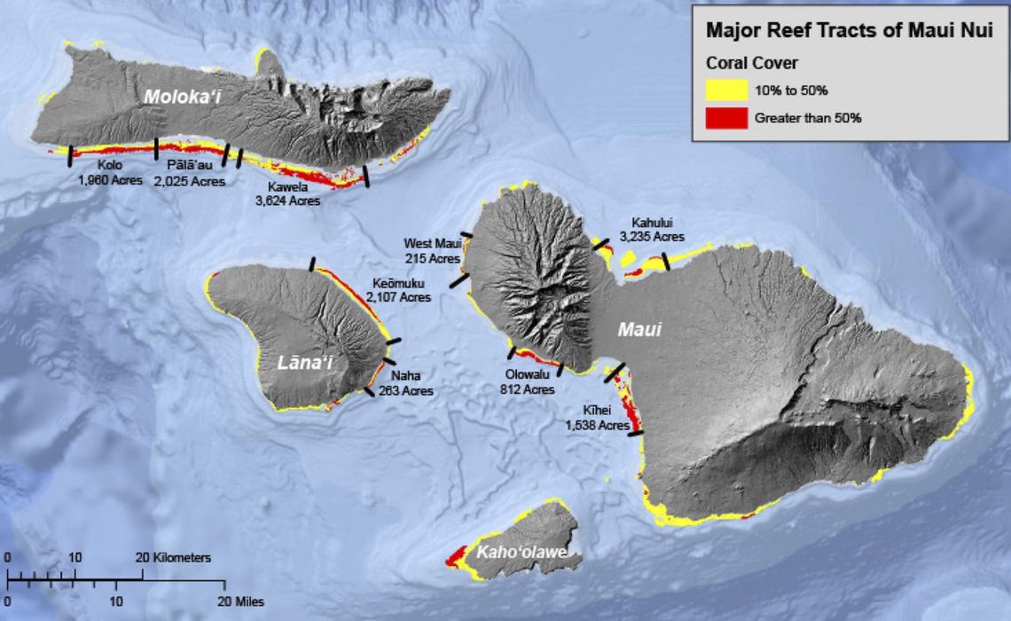
Released July 1, 2019
A new USGS Open-File Report describes the coral reefs of Maui, Moloka‘i, Lānaʻi, and Kahoʻolawe in detail, including location, extent, coral cover, and connectivity. The nine major coral reefs surrounding Maui and three nearby Hawaiian Islands (collectively Maui Nui) are critical to the local ecology, culture, and economy. Reef health has slowly declined over decades, and recent events such as the 2015 thermal bleaching have accelerated reef loss significantly, in some areas by an order of magnitude. The publication also describes threats to reef health, including overfishing, land-based pollution, and climate change. The report provides information that could inform Federal and State governments in their effort to establish a network of large-scale, connected Marine Protected Areas for effective management and protection of coral reefs in Hawai’i. Citation: Field, M.E., Storlazzi, C.D., Gibbs, A.E., D’Antonio, N.L., and Cochran, S.A, 2019, The major coral reefs of Maui Nui, Hawai‘i—Distribution, physical characteristics, oceanographic controls, and environmental threats: U.S. Geological Survey Open-File Report 2019–1019, 71 p., https://doi.org/10.3133/ofr20191019. Baseline Assessment for Coral Reef Community Structure and Demographics on West Maui
Detailed assessment of coral condition in West Maui to provide baseline for understanding changes in coral health that may result from mitigation actions by R2R
Released Spring 2017 Citation: Baseline assessments for coral reef community structure and demographics on west Maui. Data Report. NOAA Fisheries Pacific Science Center, PIFSC Special Publication, SP-17-001, 44p. |
Pharmaceuticals and Personal Care Products in Passive Samplers at Seven Coastal Sites off West Maui, Hawai‘i
Open-File Report 2022–1065
Passive membrane samplers—semipermeable membrane devices and polar organic chemical integrative samplers—were deployed for 22 continuous days at 7 sites along the West Maui, Hawaiʻi, coastline in February and March 2017 to assess organic contaminants at shallow coral reef ecosystems from diverse upstream inputs. The distribution of organic compounds observed at these coastal sites showed considerable variability; high concentrations of microbially sourced organic compounds observed at all sites, with pentadecane as the predominant normal alkane, showed the relative importance of marine and microbial organic matter to the coastal carbon pool. Pharmaceuticals and personal care products, as well as flame retardants, were also detected at all sites. Of the seven sites sampled, Kahekili Beach Park site had the highest number of unique contaminants and the Honokōwai Stream site had the highest concentrations of compounds. Two individual compounds, a flame retardant and a fragrance, were ubiquitous across the studied West Maui reefs, including at the least-developed site. A direct correlation to upstream land-use practices or legacy agricultural inputs was not readily observed since polychlorinated biphenyls, pesticides, herbicides, or insecticides were not detected. Results provide a snapshot of relative contaminant abundances as well as inputs to select nearshore environments along the West Maui coastline captured during the 2017 wet season, which was drier than expected. These data can be useful for understanding the range of stressors potentially affecting nearshore ecosystems, such as groundwater inputs and watershed runoff. Campbell, P.L., Prouty, N.G., and Storlazzi, C.D., 2022, Pharmaceuticals and Personal Care Products in Passive Samplers at Seven Coastal Sites off West Maui, Hawai‘i: U.S. Geological Survey Open-File Report 2022–1065, 12 p., https://doi.org/10.3133/ofr20221065. Rigorously Valuing the Role of U.S. Coral Reefs in Coastal Hazard Risk ReductionOpen-File Report 2019-1027
Prepared in cooperation with the University of California Santa Cruz and The Nature Conservancy 
The degradation of coastal habitats, particularly coral reefs, raises risks by increasing the exposure of coastal communities to flooding hazards. The protective services of these natural defenses are not assessed in the same rigorous economic terms as artificial defenses, such as seawalls, and therefore often are not considered in decision making. Here we combine engineering, ecologic, geospatial, social, and economic tools to provide a rigorous valuation of the coastal protection benefits of all U.S. coral reefs in the States of Hawaiʻi and Florida, the territories of Guam, American Samoa, Puerto Rico, and Virgin Islands, and the Commonwealth of the Northern Mariana Islands. We follow risk-based valuation approaches to map flood zones at 10-square-meter resolution along all 3,100+ kilometers of U.S. reef-lined shorelines for different storm probabilities to account for the effect of coral reefs in reducing coastal flooding. We quantify the coastal flood risk reduction benefits provided by coral reefs across storm return intervals using the latest information from the U.S. Census Bureau, Federal Emergency Management Agency, and Bureau of Economic Analysis to identify their annual expected benefits, a measure of the annual protection provided by coral reefs.
Citation: Storlazzi, C.D., Reguero, B.G., Cole, A.D., Lowe, E., Shope, J.B., Gibbs, A.E., Nickel, B.A., McCall, R.T., van Dongeren, A.R., and Beck, M.W., 2019, Rigorously valuing the role of U.S. coral reefs in coastal hazard risk reduction: U.S. Geological Survey Open-File Report 2019–1027, 42 p., https://doi.org/10.3133/ofr20191027. Assessing the Resilience of Leeward Maui Reefs to Help Design a Resilient Managed Area Network
Released March 2019
The project team assessed the relative resilience of reef sites at two depths along areas of West and South-West Maui ("leeward Maui") in March of 2018. The surveys were conducted as a collaborative effort with DAR, The Nature Conservancy, and community organizations. This report presents findings from meeting these project objectives: 1) assess benthic cover comparisons among sites and depths, 2) complete resilience assessment including relative resilience and rankings for two depths, 3) conduct analyses that determine the primary drivers of differences in resilience between sites, and 4) develop a framework for using the resilience analysis outputs to identify and prioritize potential management actions to support the resilience of coral reefs in Maui. Two page summary available here. Citation: Maynard J, Conklin E, Minton D, Williams GJ, Tracey D, Amimoto R, Carr R, Fielding E, Lynch H, Rose J, Sparks R, Sylva R, White D. (2019). Assessing the Resilience of Leeward Maui Reefs to Help Design a Resilient Managed Area Network. NOAA Coral Reef Conservation Program. NOAA Technical Memorandum CRCP 33, 40 pp. 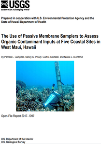
The Use of Passive Membrane Samplers to Assess Organic Contaminant Inputs at Five Coastal Sites in West Maui, Hawaii Released July 2017
|
Kahekili Reef Studies
2018 Update: Kahekili Herbivore Fisheries Management Area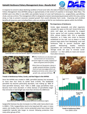
|
Coral Skeleton δ15N as a Tracer of Historic Nutrient Loading to a Coral Reef in Maui, HawaiiExcess nutrient loading to nearshore environments has been linked to declining water quality and ecosystem health. Macro-algal blooms, eutrophication, and reduction in coral cover have been observed in West Maui, Hawaii, and linked to nutrient inputs from coastal submarine groundwater seeps. Here, we present a forty-year record of nitrogen isotopes (δ15N) of intra-crystalline coral skeletal organic matter in three coral cores collected at this site and evaluate the record in terms of changes in nitrogen sources. Our results show a dramatic increase in coral δ15N values after 1995, corresponding with the implementation of biological nutrient removal at the nearby Lahaina Wastewater Reclamation Facility (LWRF). High δ15N values are known to be strongly indicative of denitrification and sewage effluent, corroborating a previously suggested link between local wastewater injection and degradation of the reef environment. This record demonstrates the power of coral skeletal δ15N as a tool for evaluating nutrient dynamics within coral reef environments.
Murray, J., Prouty, N.G., Peek, S. et al. Coral Skeleton δ15N as a Tracer of Historic Nutrient Loading to a Coral Reef in Maui, Hawaii. Sci Rep 9, 5579 (2019). https://doi.org/10.1038/s41598-019-42013-3 |
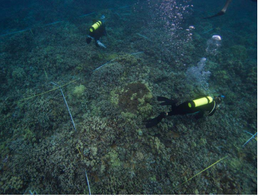
Characterization of dead zones of Porites compressa along Kahekili Beach Park Kahekili Beach Park in Kaanapali, Maui, was selected as the study site based on the 40% loss of coral coverage documented through DAR/CRAMP monitoring from 1995 to 2005, recent evidence that sewage effluent is being introduced to the reef via injection wells, and observations of areas of discrete areas of nearly 100% loss in coral cover known as “dead zones”. “Dead zones” are characterized by low coral cover with high abundance of standing but dead coral skeleton. Low coral coverage alone is not necessarily indicative of degradation. The presence of standing but dead skeleton and rubble suggest that live coral coverage used to be present but has been degraded through historical mortality events.
Ross et.al 2012. |
Mapped Products
The West Maui Coastal Uses Participatory Mapping Project was conducted as a partnership of DAR, NOAA PIRO and NOAA PSC. The project has mapped significant human uses (including range and intensity) of the nearshore area to inform resource management. See maps of where people are fishing, jet skiing, surfing and many other uses in an interactive format.
|
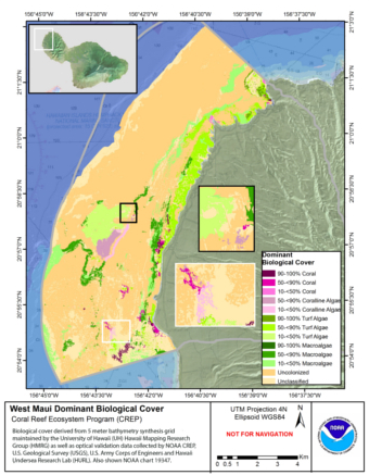
Detailed maps of West Maui Reefs from the Pacific Islands Benthic Habitat Mapping Center
|
West Maui Wahikuli and Honokōwai Priority Watershed Area
REEF CONDITION REPORT 2016 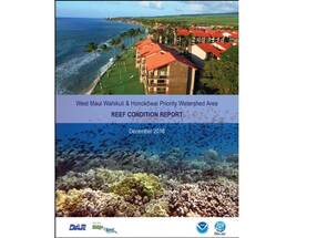
|
Guidance for Watershed Managers
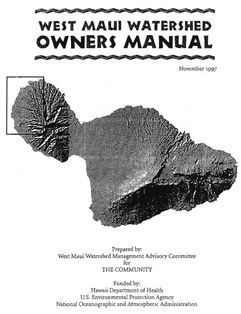
Watershed StewardshipCreated in 1997 through the community based West Maui Watershed Management Advisory Committee is the West Maui Watershed Owners Manual. Despite the changes to our land use patterns and environmental challenges since its release, this guide written for the community still contains highly relevant advice about actions anyone living, working or playing in West Maui can take to make a positive difference. This was funded by the DOH, USEPA and NOAA.
|
|
Links to Partner Agencies & Organizations
NOAA Coral Reef Program: http://coralreef.noaa.gov/
DLNR Department of Aquatic Resources: http://www.hawaiicoralreefstrategy.com/ U.S. Army Corps of Engineers: http://www.poh.usace.army.mil/ Hawaii State Department of Health: http://health.hawaii.gov/ U.S. Environmental Protection Agency: http://www.epa.gov/ U.S. Geological Survey: http://www.usgs.gov/ U.S. Fish and Wildlife Service: http://www.fws.gov/ National Fish and Wildlife Foundation: http://www.nfwf.org/coralreef/Pages/home.aspx#.U8SnrrHCd8E Hui O Ka Wai Oka: https://www.huiokawaiola.com/ West Maui Mountains Watershed Partnership: http://www.westmauiwatershed.org/ The Nature Conservancy: http://www.nature.org The Coral Reef Alliance: http://www.coral.org/ County of Maui: http://www.co.maui.hi.us/ Maui Nui Marine Resource Council: http://www.mnmrc.org/ |
The USGS Pacific Coastal & Marine Science Center has conducted considerable research in West Maui on topics such as coral larval dispersal, coastal circulation and sedimentation patterns, the impact of sediments and much more. Check out the link dedicated to work on Maui. |